

(IITM: Q++ has previous mentioned that it’s possible that planes are using technology to 3D map people’s homes, from airplanes. How widespread is the microwave tech. used against the people?… Hmmmm… do you hear any ringing in your ears that comes and goes? It could be related. Now, I don’t know about you but I’m feeling this whole surveillance culture has gone completely out of hand… because we are not using technology to always create a safer situation… people use technology to hurt and control people, and for that, we should be watchful for… get up-to-date on how and why it’s happening, how to mitigate it’s effects, and how to prevent it.)
Q++: Called the Livermore airport where the Flight Radar24 app showed these cessna’s
that are slowly mapping the entire Santa Clara County (Silicon Valley), the manager
told me those are Almeda County Sheriffs Planes (suggesting they were looking
for weed, many Mexicans in CA illegally, they grow unlicensed up in mountain ranges,
although these planes are mapping neighborhoods (not forest or mountain tops) hence I can only draw a conclusion these fuks are mapping people in their homes,
they can tell everything you’re doing, bastards have see-thru wall cameras & IR cameras as well as download links to patrol cops and news stations, we are being
logged in police databases illegally, the microwave being used is 12Ghz sufficient to
hurt your brain and organs, they well could be deploying microwave mind control !
|
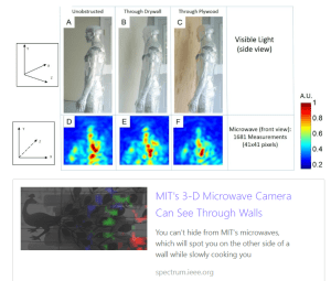
You can’t hide from MIT’s microwaves, which will spot you on the other side of a wall while slowly cooking you
spectrum.ieee.org
|

")


